Page Four
MAIN PAGE | PG. 2 | PG. 3 | PG.4 | PG.5 | PG.6 | PG. 7 | PG. 8 | PG.9![]()
Want your own piece of Beach Haven that you can call "home"? Love the bay area near where the Lucy Evelyn once stood? Check out the exciting "Bay Club of Beach Haven". CLICK HERE
There was a day, near Ninth and Bay...
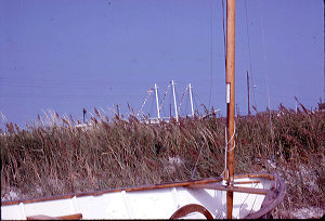 Proudly standing tall above
the swaying bay grass, the Schooner Lucy Evelyn (left, in 1971)
always appeared as if it were at sea. Only when you approached it
did you realize that it was firmly sitting on the sands of LBI.
Proudly standing tall above
the swaying bay grass, the Schooner Lucy Evelyn (left, in 1971)
always appeared as if it were at sea. Only when you approached it
did you realize that it was firmly sitting on the sands of LBI.
When I was young, our parents would occasionally take a break from spending the day at the ocean and bring us to the Taylor Avenue bay swimming area. There, with inflatable rafts and inner tubes from old truck tires, we would float in the bay for hours, waiting for boat wakes to provide some gentle "waves". The area featured a large bath house for changing and showering plus a complete playground.
To those, like us, who used to go to the Taylor Avenue beach, a visit to the schooner Lucy Evelyn was a must. And, up until 1972 when she was destroyed by a fire, it was probably an annual tradition for you too. The ship literally dominated the horizon as you faced it. Those who recall those days might think that everything that you knew back then in that area has disappeared. But you'd be wrong! The ship was just one of the shops you could visit. The location was just as famous for its small "Seaman's Shacks" which held many gift shops. Well, you have to use your memories to picture the Lucy Evelyn there today, but you can still visit one of the old wooden "shacks" that used to be dwarfed by the impressive ship.
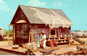
The old postcard (note old cars in photo) boasts: "Seaman's Shack. One of Long Beach Island's Oldest Houses". In an obviously staged moment, "Captain Whitepants" is letting his young visitor listen to the sea in the shell held to her ear.
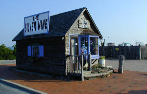
The old seashell
shack (left) has been rotated 90 degrees, so instead of facing
south it now faces east. And instead of stocking seashells, you
can now "shell" out some money to buy some custom
clip-on sunglasses. (When
my "Now" photo was taken, it was a jewelry store.) The
old building should still look familiar to the seasoned Beach
Haven visitor. And it should be remembered for its baskets full
of exotic shells and maritime artifacts that people would
purchase.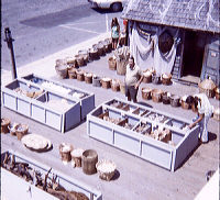 This building is truly a link to the past! Recently, while going
through some of my old transparencies (color slides), I found the
image on the right - reminding me just how many baskets and boxes
of shells were at the shack. Taken in July 1971 from the top deck
of the Lucy Evelyn, it would be the last summer for the old
schooner. And this photo shows just how close the now-surviving
shack was to the ship that would soon be destroyed by flames.
This building is truly a link to the past! Recently, while going
through some of my old transparencies (color slides), I found the
image on the right - reminding me just how many baskets and boxes
of shells were at the shack. Taken in July 1971 from the top deck
of the Lucy Evelyn, it would be the last summer for the old
schooner. And this photo shows just how close the now-surviving
shack was to the ship that would soon be destroyed by flames.
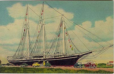 This
postcard (left) of the schooner Lucy Evelyn was mailed in 1963,
but, as is common with the long "shelf-life" of cards,
and based on the autos shown, the image is probably at least a
decade older. Please note that the Shell Shack / The Silver Mine
building shown above is just visible at the lower left
edge. No other stores were set up yet (see below).
This
postcard (left) of the schooner Lucy Evelyn was mailed in 1963,
but, as is common with the long "shelf-life" of cards,
and based on the autos shown, the image is probably at least a
decade older. Please note that the Shell Shack / The Silver Mine
building shown above is just visible at the lower left
edge. No other stores were set up yet (see below). 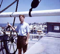
The Lucy Evelyn welcomed thousands
of visitors every year. A door on the side of the vessel allowed
you to enter the Gift Shop / Museum. In later years, the door was
covered by a lengthy enclosed corridor which shows up on some of
our family photos. That's me in 1971 on the deck (right),
squinting in the sun mere months before the ship burned down.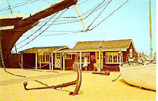
This postcard (left)
was a bit of a puzzle. It obviously shows the Lucy Evelyn and the
exterior shack shops, but the photo you see here is actually a mirror-image
of the card in my collection. (I used a computer program to
reverse it.) The way that the ship faced is correctly shown here.
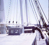 One final 1971 photo (right) shows the top
deck of the Lucy Evelyn. Photo was taken facing the boulevard.
Today, the same view would show Bay Village shops
One final 1971 photo (right) shows the top
deck of the Lucy Evelyn. Photo was taken facing the boulevard.
Today, the same view would show Bay Village shops
"Wheels and Steals"
The Beach Haven Garage and a Baseball Stadium!
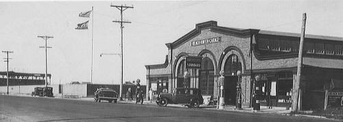 This is the
western side of Bay Avenue and Pearl Street. Behind the fence on
the left is the Beach Haven baseball field and large fan
grandstand. The garage was torn down in 1964. Here it is captured
as it looked in the 1920's...
This is the
western side of Bay Avenue and Pearl Street. Behind the fence on
the left is the Beach Haven baseball field and large fan
grandstand. The garage was torn down in 1964. Here it is captured
as it looked in the 1920's...
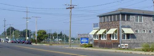 Today,
the huge garage has been replaced by a new building. It houses
the new location for the Giglio Awning Company. The baseball
field is still there, with tennis courts added and grandstand
torn down.
Today,
the huge garage has been replaced by a new building. It houses
the new location for the Giglio Awning Company. The baseball
field is still there, with tennis courts added and grandstand
torn down.
Photo was taken from the eastern side of Bay Avenue, north of Pearl Avenue.
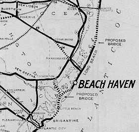 The rare and fascinating map on the right comes from
a 1930's promotional brochure touting the many marvels of Beach
Haven. What is surprising are the "dotted line"
indications of three proposed building projects. One, a
"straight to LBI" extension of what is now Route 72
from Cedar Bridge to the island was actually done.
The rare and fascinating map on the right comes from
a 1930's promotional brochure touting the many marvels of Beach
Haven. What is surprising are the "dotted line"
indications of three proposed building projects. One, a
"straight to LBI" extension of what is now Route 72
from Cedar Bridge to the island was actually done. (The Civilian Conservation Corps (CCC) was a public works program that put over three million young men and adults to work during the Great Depression of the 1930's and 1940's in the United States.)
MAIN PAGE | PG. 2 | PG. 3 | PG.4 | PG.5 | PG.6 | PG. 7 | PG. 8 | PG.9![]()
Copyright 1999-2012 Bruce A. Clark SixOfOne AT netreach DOT net