PAGE SIX
MAIN
PAGE | PG. 2 | PG. 3 | PG.4 | PG.5 | PG.6 | PG. 7 | PG. 8 | PG.9![]()
Aerial Maneuvers

Today, when beachgoers sit on the sand in the summer, it is a common sight to hear - and then see - single engine airplanes struggle up and down the coastline, pulling huge billowing banners or narrow streamer advertisements behind them. But, there was a day when there weren't so many aircraft in the sky, and those that were there had a different "mission". Ever wonder what those early pilots saw? Well, luckily, aerial view postcards have always been popular!
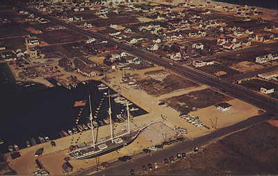
Above:
The Bay Village area in the 1950's.
Note all of the empty lots!!
Aerial photography yields the most fascinating of "historical" photographs because they enable the viewer to put an entire area in perspective. They often show areas that may not be featured in ground-level photos.
While I am unable to compare these photos to pictures taken now, (without perfecting my Kite-Cam or renting my own airplane!), these images still make for fascinating viewing.
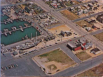
Above:
A similar 9th & Bay view from
the 1960's as Bay Village starts to take shape.
 It is sometimes hard to
imagine just how much undeveloped land there was just a few
decades ago. The postcard at left clearly shows plenty of open
space including the area near 9th and Bay where Bay Village is
today. This postcard shows a unique time - after the original
Engleside Hotel was demolished and before the new Engleside,
closer to the ocean, was built. Just look at the vacant land!!
It is sometimes hard to
imagine just how much undeveloped land there was just a few
decades ago. The postcard at left clearly shows plenty of open
space including the area near 9th and Bay where Bay Village is
today. This postcard shows a unique time - after the original
Engleside Hotel was demolished and before the new Engleside,
closer to the ocean, was built. Just look at the vacant land!!
It is amazing how the human mind can look at a photo taken from hundreds of feet in the air and recognize areas just as if we were mapping the buildings and streets in our minds or strolling down a familiar street..
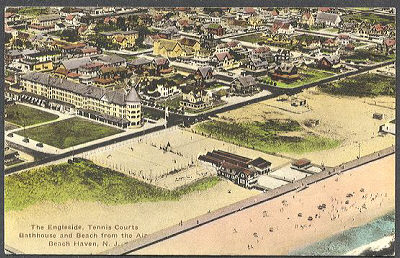
At right is the old Engleside Hotel from the air showing off its tennis courts (where the current Engleside is today). The old Engleside stood where Bicentennial Park is today, with the grand old hotel taking up the space on the northern edge of the lot. Note the boardwalk and bathhouse and the beach speckled with people. View is from the 1940's. Where the Engleside tennis courts stood is the current location of the new Engleside! Many of the cottages shown here still stand today.
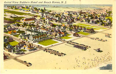
Just south a few blocks, the reverse "L" shaped Baldwin Hotel appears in the left center of this postcard. This is the hotel with the horse-drawn trolley shown on page three of this site. The large expanse of beach is misleading as now there has been much building on what was once open property.
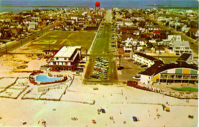
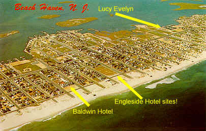
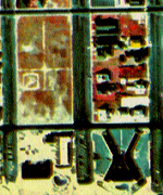
The view at right shows the new Engleside Hotel (left center, with blue swimming pool), one block nearer the beach than the old Engleside Hotel was. Bicentennial Park, with its baseball diamond clearly visible, was the site of the old Engleside. The location now hosts Craft Fairs and other summer events and boasts a gazebo. The "X" shaped motel on the right of the picture (Sea Shell Motel) still operates. You'll see a fascinating image of this area down below!
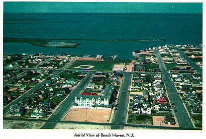
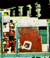
The backwards "L" shaped (and white-faced) Baldwin Hotel dominated the southern part of town until it was destroyed by a fire. Note Mordecai Island in the bay and the baseball diamond etched in the grass which survives to this day. This photo dates back to the early 1960's. The red-roofed Little Egg Harbor Yacht Club can be seen along the water's edge.
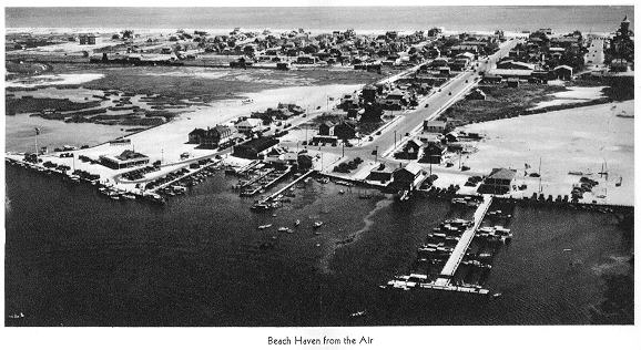
This image was used in a rare, 1930's brochure for Beach Haven. The photo features an airplane which is flying over the bay, and looking down over the growing town of Beach Haven. Note the old water tower in the upper right corner!
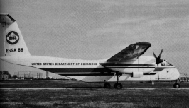
It isn't only advertising banner planes and commercial photographers that fly over Long Beach Island. Even our own federal government gets into the act!
At precisely 11:58am Eastern Daylight Time on a crystal-clear September 1969 morning, an unassuming twin-turboprop De Havilland Buffalo plane from the United States Department of Commerce flew directly over Beach Haven. Cruising at an altitude of precisely 7,500 feet above the unsuspecting town, it remained virtually unnoticed by the residents. At least, no one suspected that their own government was aiming sophisticated high-resolution cameras at them!
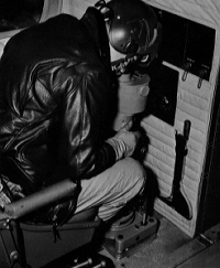 Looking very much like an Air Force
bombardier, the second officer took control of the autopilot at
the navigator position and guided the aircraft along the
predetermined flight path during the photography operation. Here
(at left) he peers down through a drift sight as the three aerial
cameras (below right) stand ready to snap highly detailed photos
of the town.
Looking very much like an Air Force
bombardier, the second officer took control of the autopilot at
the navigator position and guided the aircraft along the
predetermined flight path during the photography operation. Here
(at left) he peers down through a drift sight as the three aerial
cameras (below right) stand ready to snap highly detailed photos
of the town.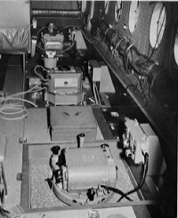
The government plane had been specially modified to carry three cameras that would handle color, black and white and infrared film. The cameras could hold up to 280 feet of spooled film 9½ inches wide, but shorter 100 foot lengths were usually used to help ease the workload on the motors of the unique processing equipment that had to be used. These rolls yielded between 90 and 100 square frames, each nine inches on a side. Picture that - a nine inch square negative! Take that to your one-hour photo lab!!
The use of infrared film (also known as false color or camouflage detection film) was often used as its characteristics were useful in investigations dealing with geology, mineralogy, forestry, agriculture and pollution studies. The photo you will see below is one of these infrared images.
The mission of the National Ocean Survey was to compile and revise nautical charts, for inshore hydrographic surveys and for other reconnaissance and scientific work.
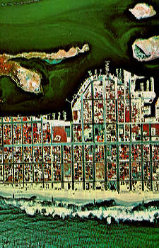
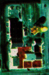
 The rare infrared
photo (at left) shows the results of the successful September
22nd,1969 fly-over. With a much-larger Mordecai Island then
(upper left in the bay) and the white foam of waves reaching the
shoreline of the mostly undeveloped oceanfront property at the
bottom, this high resolution image is remarkable in its detail
(right). The upper left block is now Bicentennial Park and the
well-worn sandlot baseball diamond basepaths dug into the dirt
can clearly be seen. Below that is the new "L" shaped
Engleside Hotel with their kidney-shaped swimming pool. To its
right is the "X"-shaped Sea Shell Motel and the block
above it shows homes and the current location of the Long Beach
Island Historical Association.
The rare infrared
photo (at left) shows the results of the successful September
22nd,1969 fly-over. With a much-larger Mordecai Island then
(upper left in the bay) and the white foam of waves reaching the
shoreline of the mostly undeveloped oceanfront property at the
bottom, this high resolution image is remarkable in its detail
(right). The upper left block is now Bicentennial Park and the
well-worn sandlot baseball diamond basepaths dug into the dirt
can clearly be seen. Below that is the new "L" shaped
Engleside Hotel with their kidney-shaped swimming pool. To its
right is the "X"-shaped Sea Shell Motel and the block
above it shows homes and the current location of the Long Beach
Island Historical Association.
I wish that I could show each individual block up-close as they are all so unique. And many probably show places where you may have stayed in or your that your family owned.
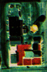
 At
left is an image showing the Little Egg Harbor Yacht Club
building (upper left corner, "yellow" roof on this
infrared film), plus the surrounding area. The nearby baseball
field and tennis courts are clearly visible from 7,500 feet in
the air and they still exist today.
At
left is an image showing the Little Egg Harbor Yacht Club
building (upper left corner, "yellow" roof on this
infrared film), plus the surrounding area. The nearby baseball
field and tennis courts are clearly visible from 7,500 feet in
the air and they still exist today.
Believe it or not, there is another "dimension" to this government project. By putting two images that were taken only seconds apart side-by-side and using special glasses, you can actually see a startling 3-D stereogram! I have seen the effect with two of these rare Beach Haven images and it is quite amazing. While I can't provide you with the necessary 3-D glasses here, I will show you a small portion of two consecutive photos of the Beach Haven water tower to show you the differences in angles that make the 3-D image appear with the glasses.
 The left photo shows the
approach to the water tower and the right photo shows it one
second later,as the plane is directly over it. Using the special
stereo glasses, your mind is fooled into seeing the tower as a
solid object, standing up from the photograph. The reddish area
is where the Borough Hall buildings are. Bay Avenue is at the
bottom.
The left photo shows the
approach to the water tower and the right photo shows it one
second later,as the plane is directly over it. Using the special
stereo glasses, your mind is fooled into seeing the tower as a
solid object, standing up from the photograph. The reddish area
is where the Borough Hall buildings are. Bay Avenue is at the
bottom.
I hope you have enjoyed this brief glimpse at aerial photography over Long Beach Island and that the next time you hear the roar of a plane's engine you'll take a moment to look up and smile. (And stand still, for Pete's sake!)
SPECIAL REPORT:
Primitive Arrowhead/Spearpoint unearthed on Long Beach Island!
Although this
arrowhead was not found in Beach Haven, it was
found not that far away - at a major excavation site at the
northern part of Long Beach Island. It was dug up in an area that
had been undisturbed for quite a long time. The artifact was
shown to an arrowhead dealer/expert 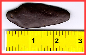 with
years of experience dealing with prehistoric items. His learned
opinion was that this is consistent with the available rock in
the area and is definitely consistent with being exposed to
moisture for a very long period of time. It could easily
have been used for hunting or fishing and based on where this was
found, it would certainly bear this theory out. Further
investigation will try to determine more about the origins of
this stone point. Updates will be posted as warranted! This could
easily be the earliest artifact ever found on Long Beach Island,
possibly dating back thousands of years...
with
years of experience dealing with prehistoric items. His learned
opinion was that this is consistent with the available rock in
the area and is definitely consistent with being exposed to
moisture for a very long period of time. It could easily
have been used for hunting or fishing and based on where this was
found, it would certainly bear this theory out. Further
investigation will try to determine more about the origins of
this stone point. Updates will be posted as warranted! This could
easily be the earliest artifact ever found on Long Beach Island,
possibly dating back thousands of years...
Copyright 1999-2012 Bruce A. Clark SixOfOne AT netreach DOT net
MAIN PAGE | PG. 2 | PG. 3 | PG.4 | PG.5 | PG.6 | PG. 7 | PG. 8 | PG.9![]()